
The maximum temperature is likely to hover above 40 degrees Celsius in the next 24 hours in many parts of the state, an official said on Wednesday.

Bihar government has sounded alert in 28 flood-prone districts following a warning issued by Indian Meteorological Department in the wake of Cyclone Phailin that pounded Odisha and Andhra Pradesh.

Over 2 lakh people living in and around the vulnerable coastal districts of Andhra Pradesh and Odisha have been evacuated with Cyclone 'Hudhud' set to hit the two states no Sunday with winds gusting up to 195 kmph.

A cyclonic circulation lies over north coastal Tamil Nadu, southeast of Bay of Bengal and a low pressure area is likely to form by November 9, the Meteorological department said on Sunday and has forecast widespread rainfall for at least the next three days in the state.

The intensity of rainfall is likely to increase with the likelihood of very heavy falls at a few places and extremely heavy falls at isolated places on May 15, reports Sanjeeb Mukherjee.

Apart from the human body, human food will bear direct repercussions. From staples such as wheat, to coffee, dairy, and even the great Hilsa face the threat of reduced supply due to the extreme heat.

After missing its deadline, the monsoon is likely to hit the national capital and parts of north India by the end of the week, a private forecasting agency said on Monday.

The name 'Laila' which means dark-haired beauty or night in Persian was suggested by Pakistan to the India Meteorological Department (IMD) which is tasked by the World Meteorological Organisation to track and name cyclones in the northern Indian Ocean, an IMD official said.

The poisonous haze has been causing significant problems for people with existing respiratory issues, according to doctors.

The CM has asked all the 51 district collectors to be alert and agile to deal with the flood situation and extend immediate help to the people in distress.

Cyclone 'Biparjoy', the first storm brewing in the Arabian Sea this year, has rapidly intensified into a severe cyclonic storm, with meteorologists predicting a 'mild' monsoon onset over Kerala and 'weak' progress beyond southern peninsular under its influence.

The weather office forecasts monsoon rains to be above average this year after the droughts ravaged crops and worsened rural distress

The very severe cyclonic storm 'Biparjoy' intensified into an 'extremely severe cyclonic storm' and is likely to cross Saurashtra-Kutch and adjoining Pakistan coasts around the afternoon of June 15 as a 'very severe cyclonic storm (VSCS)', the India Meteorological Department said on Sunday.

The same development would benefit the progress of the north-east monsoon, also known as the 'reverse monsoon'.

The finance ministry on Thursday raised concerns over the possible impact of El Nio conditions on India this year, saying if recent forecasts came true, the country could see lower agricultural output and higher inflation. "Some meteorological agencies predict the return of El Nio conditions in India this year. "If these predictions are accurate, then monsoon rains could be deficient, leading to lower agricultural output and higher prices," the ministry said in its monthly economic review.

The current spell of weak monsoon over the country is likely to continue for the next five days, the India Meteorological Department (IMD) said on Wednesday.

India is likely to experience below-normal monsoon rainfall this year, with a 20 per cent chance of drought due to the end of La Nina conditions and the potential for El Nino to take hold, private forecasting agency Skymet Weather said on Monday.

Monsoon in August was almost 24 per cent below normal, which was the sixth driest August since 1901. It came on the back of a 7-per cent monsoon shortfall in July.

Army was helping them in relief operation, Pal said, adding that around 1,200 people affected by flood were staying in five camps, including four put up in the city, he said.

Above-normal heatwave days are predicted in most parts of central, east and northwest India during this period.

The flood situation in Bihar is showing signs of improvement after the swollen rivers started receding on Friday. For nearly a week major rivers like Ganga had wreaked havoc in the state.

Over hundred dead, hundreds more being treated for sun strokes. Almost 30 crore people across India are facing the brunt of the summer heat and shortage of drinking water.

A below-normal monsoon is likely to drag down the food output with India's agricultural GDP growth likely to slump to 0.8 pc in the current fiscal, says a report by the Japanese brokerage firm Nomura.
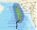
'Very severe cyclonic storm Biparjoy at 2330 hrs IST of 9th June over east-central Arabian Sea near lat 16.0N & long 67.4E. Likely to intensify further & move north-northeastwards during the next 24hrs,' the IMD said in a tweet.

The India Meteorological Department has said that the landfall process of Cyclone 'Biparjoy' has started in Saurashtra and Kutch regions of Gujarat. The landfall process will carry on till midnight with wind speeds reaching a maximum of 140 kilometres per hour, the IMD said.

Central Statistics Office has come out with GVA to measure growth.

With conditions not favouring its progress, southwest monsoon is expected to hit the Kerala coast by June 4, three days after its normal onset date, the MET department has said.

Slight tremors of 3.1 magnitude were felt in the national capital region on Monday night. The slight-intensity quake occurred at 12:41 am and the epicentre was Delhi, an India Meteorological Department report said.

The country can expect normal rainfall during the southwest monsoon season as a positive Indian Ocean Dipole (IOD) and a lower snow cover over the northern hemisphere are likely to counter the evolving El Nino conditions, the India meteorological department (IMD) said on Tuesday.

There has not been a large impact of untimely rain and hailstorm so far in several major wheat-growing areas, and those might have damaged around 3 per cent of the standing crop -- not enough to make a big dent in the expected 112 million tonnes of production in FY24, a senior government official said on Tuesday. Relentless rain pounded most North Indian states all through March. Separately, the chairman of Food Corporation of India (FCI), Ashok K Meena, told reporters the agency was on track to achieve the targeted 34 million tonnes of procurement in FY24 on the back of a strong start to the purchase season from Madhya Pradesh.

The 'eye' or centre of the cyclone is estimated to be 15 km in spread so it will take nearly an hour to cross the coast completely, officials said adding that the impact of the storm will be maximum for the next six hours

A well-marked low-pressure area over southwest Bay of Bengal intensified into a depression on Thursday morning packing wind speed of 40-50 kmph as it moved towards the north Tamil Nadu coast, the weather office said.

The cyclone is expected to make landfall on Thursday evening as a 'very severe cyclonic storm' with maximum wind speed reaching up to 150 kilometres per hour, the India Meteorological Department (IMD) said.

The IMD DG said there should not be an impression that climate change leads to rise in the temperature, but on the contrary, it leads to erratic weather.

Gujarat on Friday heaved a sigh of relief as the severe cyclonic storm 'Nilofar' further weakened and will have no major impact except moderate rains along with windy weather in some coastal areas of the state.

Exactly a year after the very severe cyclonic storm Phailin struck the state, another storm is heading towards the Odisha coast.

The Navy has has kept five flood teams and three diving teams on stand-by in Mumbai, the official said. These teams, trained and equipped for rescue operations, are stationed at various naval areas across Mumbai and can provide early response over a larger area, he said.

Unprecedented rains and floods in the northern region in the past few days have not only caused extensive damage to lives and property but have also impacted business and commercial establishments. Vegetable prices have gone through the roof in the national capital and many other parts of the country since rains started pouring earlier this month. Traders say vegetable prices would come down only after roads open and skies clear, even as water in the fields will take time to recede.

Southwest monsoon, the key to the agriculture driven trillion-dollar Indian economy, on Tuesday brought showers to Kerala bringing much-needed relief to farmers.

The benchmark index on Wednesday surged 314.92 points or 1.05 per cent to close at 30,248.17 on widespread buying spurred by forecast of a normal monsoon this year.